SPECIFICATIONS
SPECIFICATIONS
SYSTEM OVERVIEW
SYSTEM OVERVIEW
MISSION FLEXIBILITY
MISSION FLEXIBILITY
25"
33"
SENSOR OPERATIONS
Differentiators
Rapid
Autonomous
Accurate
Flexible
TACTICAL GEIGER-MODE LIDAR
WHAT IS
GEIGER-MODE LIDAR?
L3Harris' Geiger-mode LiDAR sensors deliver the most accurate high-resolution 3D geospatial intelligence (GEOINT) data available from an aerial platform for the following:
PROCESSOR
Processor
17" x 12" x 12"
SIZE
WEIGHT
POWER (max)
1,500 W
GEIGER-MODE LiDAR VS. LINEAR-MODE LiDAR
In comparison to typical linear-mode LiDAR, Geiger-mode LiDAR provides:
Advanced
COMPONENTS
Take a look inside
TACTICAL LIDAR IMAGING SYSTEM INCLUDES:
Exit Components
Boots on the ground can locate and track enemies without compromising the mission with Geiger-mode LiDAR.
Mission planning
Monitoring
Object
identification
Tactical mapping
Pilots need to find safe landing zones on land. Clear images help determine the safest locations to land and avoid obstructions like powerlines.

Mission planning
Locating and tracking enemy movement is crucial to mission success. Warfighters can maintain custody of critical targets under foliage and camouflage nets.
Monitoring
Geiger-mode LiDAR’s 3D imaging shows troops exactly what they can and can’t see before deployment. Knowing structure locations and details help you gain the best line-of-sight to minimize vulnerabilities and concerns hidden under foliage.
Object identification
This helps warfighters gain a big-picture perspective while eliminating surprises. Seeing buildings, utilities, terrain and water bodies allows troops to move quickly and safely.
Tactical mapping
>
>
>
>
>
>
Troops using this lifesaving technology have the most accurate high-resolution 3D GEOINT data offered from airborne military observation tools. They can see unmatched detail beneath tree canopies, structures in heavily populated cities, rugged mountain terrain and more.
HOME
HOME
Reliable
Superior 3D image quality of level-3 and level-4 products
Higher resolution data sets
Collection from higher altitudes
Better foliage penetration for
• Improved detection and identification of concealed targets
• Improved bare Earth topographic products
Higher accuracy due to multilook imaging concept of operations
Higher area coverage rates
SENSORS
EARLY ONBOARD PROCESSING
EXPLOITATION
DATA MANAGEMENT
DATA DISSEMINATION
END-TO-END
LIDAR SOLUTIONS

Onboard processing and downlink capabilities speed up the time between data collection and the analysts’ dashboard.
The processor combined with the LiDAR sensor payload provides a superior real-time actionable product in both day and night.
Baseline features:
Real-time point cloud formation for immediate quality assurance and control; near real-time processed data products (aggregate level 3 geo-registered point clouds colorized with LiDAR relative intensity and RGB from co-collected passive electro-optical imagery, level 4 bare Earth and reflective surface digital elevation models and relative intensity imagery); storage and access to the entire mission; LAZ v1.4 or MIPC format point clouds with GPM, GeoTIFF raster products.
100 lbs


United States Geological Survey Test Site Comparisons of Geiger-
vs Linear-mode Foliage Penetration – 1-meter Cross-section
L3Harris Geiger-mode: 12,000 feet leaf on
Riegl 680i: 3,000 feet leaf off
Leica ALS70: 7,000 feet leaf on
Imagery from IntelliEarth™ LiDAR
Example Level 3 Point Clouds - High Resolution and
High Area Coverage Rate Analyses of Sites and Compounds


Imagery from L3Harris IntelliEarth™ LiDAR
Example Level 3 Point Clouds -
High Resolution and High Area Coverage Rate


Urban Canyons
Utility Infrastructure
Volumetric Change Detection
Example Level 3 Point Clouds -
High Resolution and High Area Coverage Rate
Imagery from L3Harris IntelliEarth™ LiDAR
Towers/Cranes/Wheels
Elevated Highways & Railways
Industrial


Rugged Terrain
Transportation
Linear-mode LiDAR
Geiger-mode:
Spatial Distribution and
Sample Uniformity Comparison


L3Harris Geiger-mode LiDAR
Uniform sampling in time
Array-based detections provide raw detections at several times product density
Enables stratified sampling to create very uniformly
sampled product
>
>
>
Linear-mode:
Uniform sampling
in time
Improve uniformity at ground by modifying platform speed and scan rate
Very little control over sample spacing pass-
to-pass
>
>
>
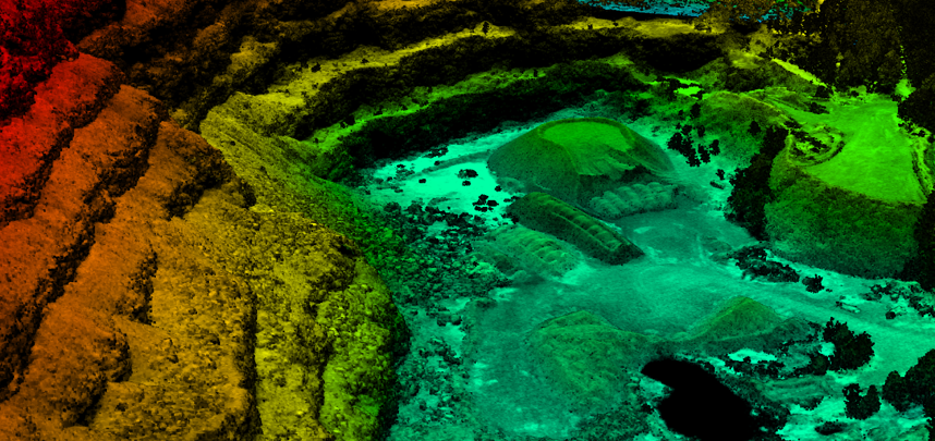
Example Level 4 Digital Surface Model - Void-less
Coverage of Extremely Rugged Terrain
Imagery from L3Harris IntelliEarth™ LiDAR

Capture Fine Linear Feature Details
from Medium Altitudes
Imagery from L3Harris IntelliEarth™ LiDAR


PRIVACY POLICY | TERMS OF USE

RETURN TO TOP
Pilots need to find safe landing zones on land. Clear images help determine the safest locations to land and avoid obstructions like powerlines.
MISSION PLANNING
Locating and tracking enemy movement is crucial to mission success. Warfighters can maintain custody of critical targets under foliage and camouflage nets.
MONITORING
Geiger-mode LiDAR’s 3D imaging shows troops exactly what they can and can’t see before deployment. Knowing structure locations and details help you gain the best line-of-sight to minimize vulnerabilities and concerns hidden under foliage.
OBJECT IDENTIFICATION
This helps warfighters gain a big-picture perspective while eliminating surprises. Seeing buildings, utilities, terrain and water bodies allows troops to move quickly and safely.
TACTICAL MAPPING
Boots on the ground can locate and track enemies without compromising the mission with Geiger-mode LiDAR.
Troops using this lifesaving technology have the most accurate high-resolution 3D GEOINT data offered from airborne military observation tools. They can see unmatched detail beneath tree canopies, structures in heavily populated cities, rugged mountain terrain and more.
MISSION FLEXIBILITY

Exit Components

COMPONENTS
Take a look inside

END-TO-END LIDAR SOLUTIONS
25"
33"


Processor
17" x 12"
x 12"
SIZE
WEIGHT
100 lbs
POWER (max)
1,500 W
Onboard processing and downlink capabilities
speed up the time between data collection and the analysts’ dashboard.
The processor combined with the WAMI sensor payload provides a superior real-time actionable product in both day and night
Baseline features:
Real-time stitching and mosaicking of area-of-interest views; additional independent controlled (roam and zoom) views simultaneously in real time, with storage and forensic access to the entire mission; full synoptic view; NITF 2.1 and JPEG 2000 encoded images; real-time full field of view (FOV) tracking.
In comparison to typical linear LiDAR, Geiger-mode LiDAR provides:
>
>
>
>
>
>
GEIGER-MODE LIDAR VS. LINEAR LIDAR

GEIGER-MODE LIDAR VS. LINEAR LIDAR
PROCESSOR

PROCESSOR
SPECIFICATIONS

SCROLL DOWN TO LEARN MORE
WHAT IS
GEIGER-MODE LiDAR?

WHAT IS
GEIGER-MODE LIDAR?
WAMI provides users with persistent surveillance over an area of interest and contains more information for analysts to see what’s happening in real time. This helps users understand a surveillance situation and its complexities.
WAMI adds context to signals intelligence by creating a visual picture of the surveillance situation in both real-time and forensic. This allows for detailed analysis of events, networks and patterns of life.
Collecting WAMI enables tracking with high-resolution color and infrared motion imagery to:
> Observe vehicle tracks and traffic
> Study patterns of life
> Identify nodes of activity and anomalous behavior
> Utilize patterns and trends to anticipate behavior

IMAGE GALLERY

TACTICAL GEIGER-MODE LIDAR
Reliable

Flexible
Advanced

Efficient

Accurate

HOME
> MISSION FLEXIBILITY
> SYSTEM OVERVIEW
> MISSION FLEXIBILITY

Flexible


Superior 3D image quality of level-3 and level-4 products
Higher resolution data sets
Collection from higher altitudes
Better foliage penetration for
Improved detection and identification of concealed targets
Improved bare Earth topographic products
•
•
Higher accuracy due to multilook imaging concept of operations
Higher area coverage rates
SENSOR
OPERATIONS
SENSORS
EARLY ONBOARD PROCESSING
EXPLOITATION
DATA
MANAGEMENT
DATA
DISSEMINATION


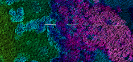
Power Transmission & Distribution Lines, Towers, & Poles
Grand Canyon
Vertical Obstruction Detection


HOME
Reduce Motion
Reduce Motion On
> Reliable ball turret
> Active thermal management
> Stabilized optical bench
> Precision pointing control electronics
> Geiger-mode LiDAR sensor
> Electro-optical/infra-red companion sensors
LiDAR Sensor Includes:
> Laser assembly
> Risley scanner
> Telescope
> GmAPD camera
> Electronics


PRIVACY POLICY | TERMS OF USE
REDUCE MOTION

> Foliage penetration
> Camouflage net penetration
> Geometrical change detection
> Volumetric analysis
> Detailed scene analysis
> Line-of-sight (viewshed) analysis
> Slope maps (dismount and vehicle mobility)
> Helicopter landing zones
> Vertical obstructions
> Flood analysis


Vertical Obstruction Detection
Power Transmission & Distribution Lines, Towers, & Poles
Grand Canyon


Industrial
Power Transmission & Distribution Lines, Towers, & Poles
Power Transmission & Distribution Lines, Towers, & Poles
REDUCE MOTION


IMAGE
GALLERY


PLAY
VIDEO

Contact Us


CONTACT US
PLAY
VIDEO


CONTACT US
PLAY
VIDEO


