AVIONICS FOR MILITARY MISSIONS
PRODUCTS
TECHNOLOGIES
PLATFORMS
PRIVACY POLICY | TERMS OF USE
Proven and Efficient Avionics Solutions
products
GH-3900 Standby
TACAN+ Navigation
SRVIVR Flight Recorders
Home
Platforms
Technologies
Products
MENU
MASS / TCAS
NXT-600 Transponders
Pilot Training
GH-4001 Standby
Established solutions for modernization
T-6A
T3CAS
NXT-700 Transponders
TCAS 3000SP
Industry Leading Technology Implementation
technologies
Detect & Avoid
Surveillance
L3Harris leverages our vast technological experience to provide next-generation surveillance solutions for UAS by integrating TCAS, Terrain Awareness, Transponders, Distance Measuring Equipment and ADS-B into a single simplified OEM unit. Our solutions provide unrivaled tactical performance, safety, and lower operating costs through reduced wiring, smaller LRUs and single antennas. In some cases, we have reduced weight by as much as 80 lbs with newer designs and advanced technology while increasing MTBF and reliability by lowering the number of spares needed on-hand.
Whether it is UAS, Helicopters, Urban Aircraft Mobility or even base stations - L3Harris is at the forefront collaborating with prominent industry leaders to launch new technologies that will advance unmanned aircraft travel well into the future. By using ACAS Xu with non-cooperative sensors, we have developed an advanced, integrated detect and avoid solution that implements directional traffic antennas and sophisticated algorithm. It evaluates impact risk and automatically executes effective maneuvers to avoid air and terrain collisions for unmanned aircraft. This technology is the cornerstone for safe and effective urban air mobility.
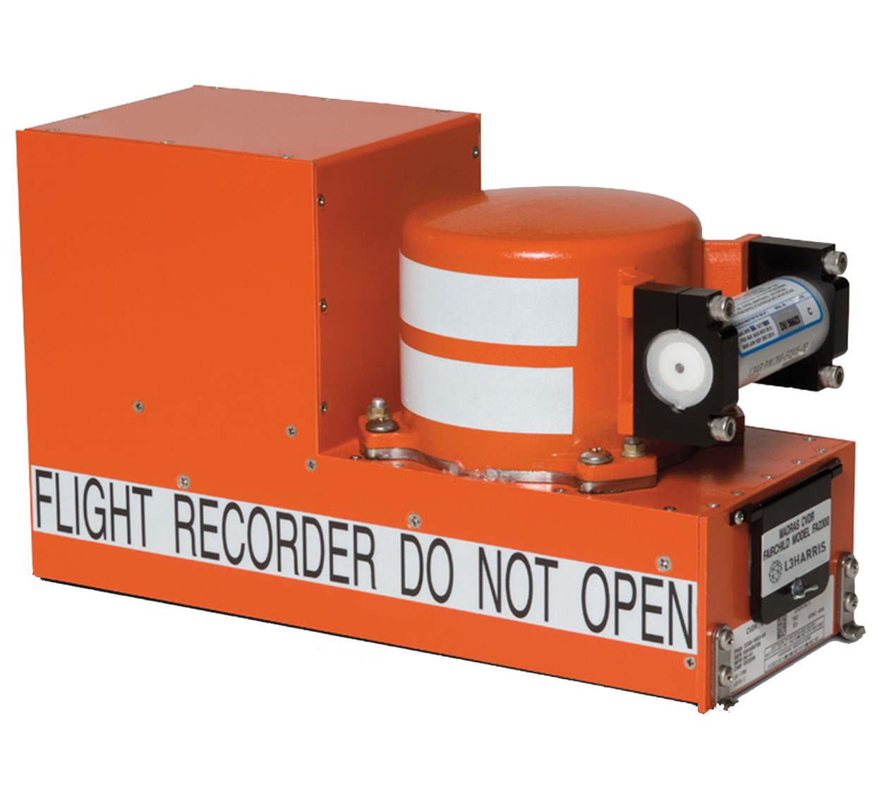
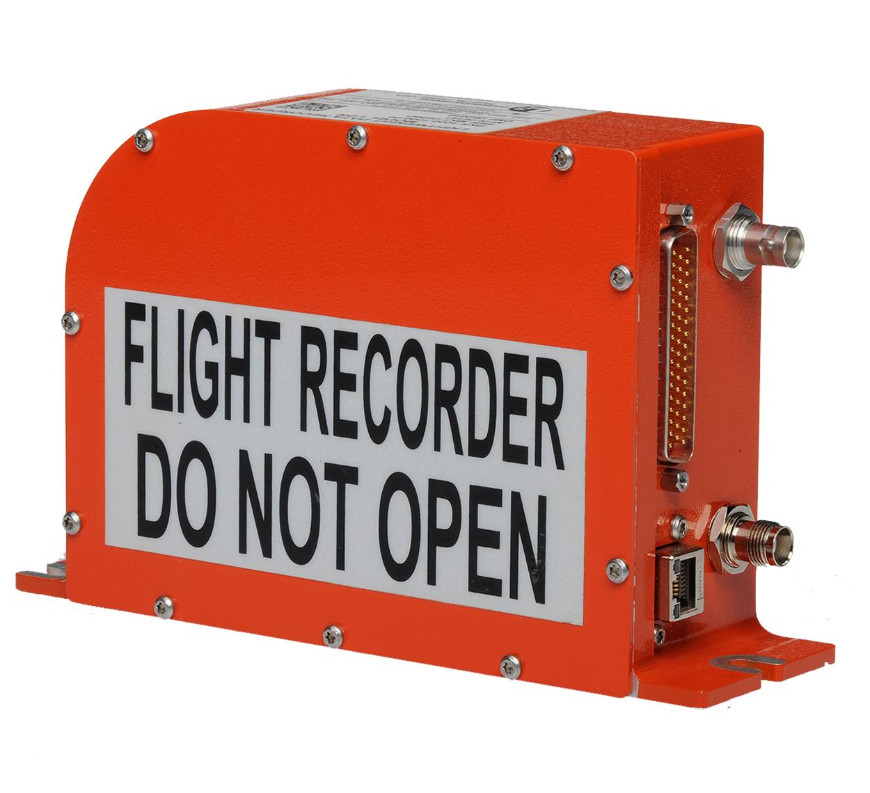
As an industry leader for cockpit voice and flight data recorders for nearly sixty years, L3Harris currently has lightweight and quick access recorders with crash-survivable memory and a history of 100% data recovery. To meet the demands of unmanned aircraft, our advanced development team is developing new recorders that are compact in size, but robust enough to store hundreds of hours of flight data and video.
Flight Recorders
L3Harris currently provides the world’s lightest and smallest tactical airborne navigation system for commercial and military use, including unmanned systems, weighing at 5.2 pounds. The TACAN+ is the only navigation solution available with the capability to track up to four ground stations simultaneously in range and two in bearing with a tracking velocity is up to 1800 knots. Used for both Air-to-Air and Air-to-Ground operations, the TACAN+ employs software-controlled antenna switches and dual antennas if needed.
Navigation
L3Harris provides terrain awareness and warning solutions, all built on a unique set of advanced prediction and avoidance technology that provides alerts for terrain and obstacles in and around the flight path. Our solutions provide warnings based on the unique flight performance of the aircraft including climb capability and a combination of active traffic in the same view as terrain. Additional capabilities include avoiding terrain and engine-out details which encompass terrain, obstacles and airport databases. The most notable feature of the L3Harris TAWS systems is the ability to offer a higher level of safety by basing alerts on an aircraft’s actual ability to climb. This sophisticated modeling of aircraft climb capability provides the most complete picture for enhanced situational awareness for manned and unmanned aircraft.
Terrain Awareness
L3Harris has over twenty years of experience as the largest provider of Flight Data Monitoring (FDM) and analysis for all operators. Flight Data Connect incorporates FDM and Flight Operations Quality Assurance (FOQA) into an intuitive, proven and secure web-based platform. You can quickly identify unsafe events on a regular basis, which allows you to incorporate actions or additional crew training needed immediately. Additionally, maintenance data directly assists in cost savings by highlighting inefficiencies and preventative maintenance needs, which can immediately reduce AOGs and operational delays.
Flight Data
platforms
Fixed Wing
UAVs
Helicopters
MQ-9B MQ-25 MQ-9 MQ-4C RC-4B
UH-60 UH-72 T-129 AH-1
F-35 F-15 C-130J KC-46 E-6 F-18 F-16
Progressive Efficiency and Safety Solutions
P-8 C-27J A400M PC-21 T-6 KC-90
AH-6i AH-64 CH-46 CH-47 V-22
MODELS
RELATED PRODUCTS
SPECIFICATIONS
7.29"
5.75"
MISSION READY
SRVIVR ensures retrieval of your precise data and minimizes the risk of inaccurate or corrupted data, regardless of the environment.
Differentiators
Flexible
Reliable
BENEFITS
KEY FEATURES
> Innovative data acquisition and flight data recording protects data > Reduces size, weight and lower power requirements reduces costs > Flexible architecture for aircraft specific configuration provides fleet commonality > Offers FIPS 140-2 Level 2 encryption provides data security > Easily retrieve data through Ethernet connection reduces maintenance time
PHYSICAL
Secure
SRVIVR COCKPIT VOICE AND DATA RECORDER (CVFDR)
SRVIVR PLUS CVFDR
eSRVIVR ENCRPTED CVFDR
> 2-Hours Audio Recording > 2-Hours Flight Data Recording > 2-Hours CNS/ATM Data Link Recording > Offers Range of Avionics Interface for Direct Communications
FLIGHT DATA SERVICES (FDM/FOQA AND MAINTENANCE)
OVERVIEW
BROCHURE
Compact
Proven, world-class technology in a lightweight, survivable package
> Innovative data acquisition and flight data recording protects data > Reduces size, weight and lower power requirements reduces costs > Flexible architecture for aircraft-specific configuration provides fleet commonality > Level 2 encryption for maximum data security > Ethernet connection for reduced maintenance time > Provides cooperative member identification using Mode A or Mode 2 Flight ID codes enabling viewing of user-selected aircraft data
> Adds the Functionality of a Flight Data Acquisition Unit (FDAU) > Meets the Qualification Requirements of MIL-STD-810, MIL-STD-461 and MIL-STD-704
> Offers Optional FIPS-140-2 Validated Encryption to Level 2 > Single Line Replaceable Unit (LRU) > Retrieve Data via Ethernet Download
OTHER CVR, FDR AND CVDR RECORDERS
FA2200/2300
Light Data Recorder
FA2100
FA5000
FA5300
Express Readout
Flight Data Connect
SRVIVR COCKPIT VOICE AND FLIGHT DATA RECORDERS
3.25"
> Input Power: +16-32 VDC, MIL-STD-704F > Main Connector: MIL-C-38999 SERIES II > Storage Capacity: 4 GB > Crash-protected, solid state memory
PHYSICAL specifications
> Operating: -55 to +71 Degrees C > Non-operating: -55 to +85 Degrees C
environmental
> 90-day beacon > TSO-C-121b > Six-year battery & bracket supplied
underwater Acoustic Beacon
> FIPS 140-2 validated > Level 2 encryption (NIST) >Tactical key erase via discrete input
eSRVIVR VALIDATION
> Penetration: 500 lb. / 10 FT. (.25" probe) > Static Crush: 5,000 lb. > Fire Protection: 50,000 BTU/sq. ft./hr. for 60 min @ 1,100 degree C > Impact Shock: 3,400g, 6.5 ms, half-shin shock wave > Immersion Seawater @ 20,000 ft. for 30 days > Aircraft and fire extinguishing fluids for 48 hrs.
CRASH SURVIVABILITY (ED-122)
> Cockpit Audio, 4 inputs > Rotor Speed, 1 input > ARINC 429, up to 4 inputs > Arinc 777, RIPS interfaces > Ethernet 10/100 Base-T with TCP/IP, UDP/IP and FTP > MIL-STD-1553B, 2 dual-redundant busses > RS-22 Channels, 4 monitor channels > 24 Analog Inputs > Discrete inputs, 36 recorder or control inputs
Aircraft Interface options
VALIDATIONS
options
SURVIVABILITY
* Note: Product information varies per SRVIVR model, please contact your representative or www.L3Harris.com/avionics for more information.
BACK
TCAS 3000SP T3CAS TACAN+ SRVIVR GH-4001 NXT-7000 TRAINING
8.33"
3.19"
The GH-3900 provides customizable configurations and pilot-defined interfaces to enhanced pilot performance and safety if aircraft flight displays fails.
> Provides maximum safety using a full-function Attitude Direction Indicator (ADI) > Delivers ultimate display and operation flexibility using pilot-defined interfaces > Provides critical awareness through customizable indicators and configurable flight cues, colors, and data > Conserves cockpit space using a compact system that fits in virtually any cockpit environment to maintain consistency within fleet > Enhances pilot situational awareness by displaying speed awareness cues for Part 23/25 aircraft and 27/29 helicopters
GH-3900 Electronic Standby Instrument System (ESIS)
GH-3900 (Internal ADC)
GH-3900RSU ESIS Remote Sensor Unit
> Full-function ADI standby system > Field-loadable software > LED backlit display and controls > Certified multiple ARINC 429 outputs > Solid-state design increases reliability and reduces repairs
Customizable and compact standby display designed for virtually any aircraft
> Flexible configuration and compact design permits installation in even the tightest spaces > Reduced size, weight, and power requirements lower operational costs > Pilot-defined color options and visual cues offer unmatched display personalization of flight data > Preferences are integrated into wiring harness, eliminating separate configuration modules > Optional magnetometers for heading offer advanced capabilities > Configuration with ADCs or optional ADC-4000 offers legacy aircraft advanced data sharing
> Added internal Air Data Computer (ADC) > Configured with an internal ADC or a remote ADC > Available for operators of legacy aircraft > Designed to share air data with other instruments
> Two Box System Designed for Cockpit Flexibility > 4.2-inch Diagonal High Resolution Display (DU-42) > Separate Remote Sensor Unit (RSU) > Installs in Limited Space (1.5” Deep) > Configurable I/O Interfaces
OTHER STANDBYS Solutions
GH-4001
GH-4200
efd-750
esis-5000
GH-3900 Electronic Standby Instrument SystemS
Chassis Dimensions: >8.33" length x 3.19" width x 3.19" height Overall Dimensions > 9.63" length x 3.28 width x 3.28" height > Weight: 3.0 lb. max (1.36 kg) > Input Power: Dual 28 VDC inputs (18 VDC emergency power) > Interfaces: ARINC 429, RS-422, RS-232, discrete and analog > Navigation: VOR/ILS, DME, FMS/GPS, TACAN, ARINC710 ILS > Supports multiple input/output data transfer protocols
> C2d, C3e, C4c, C6e, C8e, C10b, C34e, C35d, C36e, C40c, C46a, C66c, C95a, C106, C113, C115b
Tso
> C2d, C3d, C4c, C6e, C8e, C10b, C46a, C95a, C106, C113, C115b, 2C34f, 2C35d, 2C36f, 2C40c, 2C66b
etso
Standard & Configurable display options
> MAG-3000/MAG-3100 > Magnetometer mounted directly to the aircraft frame via three-axis magnetic sensor for heading, or compatible ARINC 429 source > ADC-4000 > Internal ADC or a remote ADC configuration to share air data
Multiple Platform Compatibility
certifications
display
* Note: Product information varies by model, please contact your representative or www.L3Harris.com/avionics for more information.
CUSTOMIZABLE
integrated
esi-500
Magnetic Heading
MAG-3100
EFD-750 Shown
GH-3900 ESIS and GH-3900 ESIS Remote Sensor Unit shown
> Time-to-Waypoint or Station > Metric Altitude > Altitude Tape > Pitch Ladder > Glideslope Scale > Vertical Speed Indicator > Barometric Pressure Selection > Market Indicator > Distance-to-Waypoint or Station > Slip/Skip Indicator > To/From Indicator
> Navigation Mode Indicator > Mach > Course Selection > Roll Scale > Airspeed Tape > Aircraft Reference Symbol > Airspeed Awareness Bands > Heading Tape > Ground Speed > Localizer Scale > Course Arrow
Web Page
Configuration Module Tool Reduces Time
8.51"
3.28"
The GH-4001/4200 empowers pilots to meet mission-critical obligations through enhanced situational awareness and advanced flight data.
> Meet the demanding needs of high performance military aircraft, including ruggedized helicopter environments > Enables enhanced pilot situational awareness and efficiency > Provides advanced flight data > Typical on-ground alignment start-up < 1 minute > Designed for single and tandem high-performance military aircraft > Enhances pilot situational awareness
GH-4200 Electronic Standby Instrument System (ESIS)
> Designed for single and tandem high-performance military aircraft > Custom engineering for additional commercial platfoms available > Repeater display available for numerous cockpit configurations > Configurable display of flight cues > 3-ATI self-contained unit weighs only 3 lb. (1.36 kg) > Interfaces support ARINC 429, RS-232 serial bus, discrete and analog inputs > Flat-panel AMLCD is sunlightreadable and NVG-compatible > High-rate attitude sensors and supersonic air data sensors > Military-qualified for rugged carrier environments > Field-loadable software
agile and dependable solutions for Military flight guidance and safety systems
> Sunlight readable Active Matrix Liquid Crystal Display (AMLCD) with LED backlight > Ambient light sensor > Illuminated menu button and knob > NVIS compatible > High rate sensors > Repeater display available for numerous cockpit configurations > Integrates with existing magnetometers > Field-loadable software and display settings > Military Qualification > ARINC 429 or MIL-STD-1553 interface
GH-3900
GH-4001/4200 Electronic Standby Instrument
Dimensions: > 8.51" length x 3.28" width x 3.28" height Weight: > 2.9 lb. max (1.32 kg) Power: > 10 W nom., 22 W max. at 28 VDC Interfaces: > ARINC 429 receivers (4) and outputs (2) > RS-232 serial bus > Discrete: 5 In, 1 Out > Pneumatic ports
> MIL-STD-810 > MIL-STD-461 > MIL-STD-704 > MIL-STD-3009
Flight Data Includes
Qualifications
> AttitudeIndicator > Mach Number > Airspeed Digital Readou > Barometric Setting > Heading Tape > Metric Altitude > Altitude Tape > Angle of Attach > Navigation > Rotor Speed
powerful
World’s lightest and smallest high-performance tactical navigation system
TACAN+ Tactical Airborne Navigation System
TACAN+ provides efficiency, reduces costs and offers flexibility to pilot. It is the only TACAN able to run four TACAN/DME ground stations simultaneously, and two in bearing, with a tracking velocity at 1800 knots.
> Delivers unprecedented tactical power with simultaneous multi-station tracking > Reduces operational costs and conserves vital aircraft weight using a lightweight and compact footprint > Provides high system reliability in harsh environments through a rugged design and military-grade testing > Provides flexibility using pilot-selectable bearing controllers and indicators > Delivers enhanced tactical capabilities across multiple flying scenarios by means of the automatic Air-to-Air (A-A) transmit-receive mode
> Interfaces with analog and digital flight instruments including ARINC 429 and MIL-STD-1553 architecture > Air-to-Air bearing capabilities > Can be used as a pilot-controlled positioning system and/or as a blind navigation sensor > Multiple input/output busses update Flight Management or Inertial Systems simultaneously > Powerful and lightweight 750 watt transceiver features a maintenance port for ease of service > TACAN+ equipped aircraft to track a ‘lead’ aircraft across a wide range of flying scenarios with a minimum closest distance of 20 meters
Features two automatically enabled Air-Air (A-A) Transmit-Receive modes providing: > Enhanced tactical capability > Multiple mission capability > Overall operational value > A-A Receiver is configured for optimal reception and tracking of the Beacon signal source If the A-A bearing signal is detected, TACAN+ enters a High Signal Dynamics 20-Meter mode: > Configured to accommodate the strongest received A-A signal > Track a ‘lead’ aircraft across a wide range of flying scenarios Not found on other TACAN products
aIR TO aIR mODE
AIR TO AIR MODE
STANDBY Solutions
GH-4200 Shown
10.75"
3.45"
Weight: > Receiver-Transmitter: 5.2 lb. max (2.36 kg) > Display Unit: 0.4 lb. (0.18kg) > Mounting Tray: 0.4 lb. (0.18kg) Size: > Display Unit: 1/2 3ATI x 6.9” (17.53 cm) > Mounting Tray: 01/2 3ATI x 6.9” (17.53 cm) > F3849 Control Unit: 2.4” x 2.8” (6.10 x 7.11 cm) > F6555 Control Unit: 2.24” x 2.8” (5.69 x 14.6 cm) Power Requirements: > Reciever-Transmitter: 18 to 32 VDC @ 1.5 amps. Max. > Display Unit: 18 to 32 VDC @ 1.5 amps. Max. > Control Units: 5 to 28 VDC @ 0.15 amps. Max.
Temperature: > Receiver-Transmitter: -54 to +71 degrees C > Display Unit: -20 to +71 degrees C > Control Unit: 0.4 lb. -20 to +71 degrees C Altitude: > Display Unit: to 70,000 feet > Mounting Tray: to 55,000 feet Power Output: > 500 watts peak minimum, 750 watts peak typical Cooling (all equipment): > Conduction & Convection
> Receiver: 962 to 1213 MHz (All 252 X and Y mode channels) > Transmitter: 1025 to 1150 MHz (All 252 X and Y mode channels) > Air-to-Air: 126 channels (63 X and 63 Y mode)
Frequency Range
> 252 (consisting of 126 X mode and 126 Y mode channels) > 126 Channels for Air-to-Air Ranging (MIL-STD-291C & NATO STANAG 5034) >Air-to-Air: 126 channels (63 X and 63 Y mode)
channels
Range: > Capability: 0.0-400 nm Tracking Capability > Accuracy: ± 0.1 nm 0 to 399.9 nm > Display Resolution: ±0.1 nm from 0.0 to 99.9 ± 1.0 nm from 100-400 nm > ARINC 568: 0.0 - 399 ± 0.1 nm Range Tracking Rate: > 0 to 1800 nm Per Hour Ground Speed (ID-2502 Display): > 0-999 Kts ± 1 Kt or 1% within 30 seconds Time-to-Station > 0-99 Minutes ± 1 minute within 30 seconds Memory Time: > 8 seconds Nominal Range and Bearing
Acquisition Time > 3-5 seconds Nominal Distance and Bearing ID Tone: > Station Ident Distance Outputs: > ARINC 568 Pulse Pair: Output limited to 204.0 nm > 40 mv/nm: Output limited to 199.9 nm > RS485 Serial Digital provides distance for all four stations simultaneously Air-to-Air: > Per Mil-Std-291C & NATO STANAG 5034
Details
Range
AIR-TO-AIR MODE
Functionality
MASS provides advanced situational awareness and efficiency for military pilots by utilizing ‘active’ TCAS II surveillance and ADS-B technologies to fulfill unique military formation flight and rendezvous operations within the Civil Airspace.
> Provides flight safety using proven commercial ADS-B and ‘active’ TCAS II technologies > Manages military-specific requirements to support flight formations and rendezvous maneuvers > Delivers superior terrain awareness and greater margin to maneuver through warnings based on the unique aircraft performance > Limits RF interference and fully ATC compliant for seamless operation in civil environments > Provides flight security using high resolution ranges for close-in operations and enhanced surveillance volume
overview
Innovative Communication and Surveillance System for Military Operations
> Integrated TCAS, ADS-B, Mode S Transponder and TAWS with Reactive Windshear System > Cooperative Flight Mode provides identification, alerting and adaptive RF power reduction for 30 formation members and rendezvous operations > Non-Cooperative Flight Mode eliminates platform clustering and altitude restrictions > Proven field performance and interoperability testing on tankers and several other platforms > Provides cooperative member identification using Mode A or Mode 2 Flight ID codes enabling viewing of user-selected aircraft data
mass military airborne surveillance system
MODE S TRANSPONDERS
> Equipped with the Class A Terrain Awareness Warning System (TAWS) integrated into the unit > Provides warnings based on the unique performance capability of an aircraft to avoid CFIT incidents > Provides operators the appropriate amount of time to clear terrain with a greater margin to maneuver > Utilizes a patented Terrain Advisory Line feature that indicates an impending alert should the aircraft continue on its flight path
Terrain Awareness Warning System (TAWS)
> Provides pilot situational awareness and TCAS for more than 15,000 aircraft worldwide > Built on the technology and expertise that has made MASS an industry standard in reliability and performance > Provides the highest bearing accuracy and range capability available > Built for performance, the surveillance algorithms deliver outstanding aircraft tracking performance > The Collision Avoidance Logic includes the most current safety upgrades (TCAS Change 7.1) > Using ADS-B technology, it enables intruder aircraft tracking at ranges of 160 NM and the implementation of TCAS Hybrid Surveillance
TRAFFIC COLLISION AVOIDANCE SYSTEM (TCAS)
saferoute+ ADS-B IN APPLICATIONS (fUTURE)
> The Mode S transponder is certified to DO-260B, and meets the global ADS-B Out mandates > Integrated RF transceiver module only requires a single antenna for Mode S mode > Allows simultaneous operation with both top and bottom transponder antennas, optimizing signal strength and reducing multipath interference
SafeRoute+ is the newest set of ADS-B applications for commercial and military use. Key features include: > Increasing safety and efficiency for flight operators > Providing pilots a precise forward field of view for aircraft up to 100 nautical miles > Displays the flight identification, position, altitude, speed and direction > Removes the guess work and manual calculations > Enables flight optimization and routing efficiency > Uses the existing Navigation Display, Multi-function Control and Display Unit and the ADS-B Guidance Display from L3Harris > Simple software upgrade to existing T3CAS and NXT units
CVR, FDR AND CVDR flight RECORDERS
cdti dISPLAY
MASS is manufactured by ACSS, an L3Harris & Thales Company
SRVIVR
4.815 inches x 6.25 inches (12.23 cm x 15.875 cm) 5.1 inches (W) x 3.8 iches (H), 6.3 inches diagonal (12.95 cm x 9.65 cm x 16.02 cm diagonal) ARINC 708A 6.5 lbs. (2.95 kg) ARINC 429 / 725 ARINC 762 / 453 ARINC 702 (growth) ARINC 568 (growth) ARINC 561 (growth) ARINC 708A, Collins WRX-700X, Honeywell RDR-4A / RDR-4B 55,000 Ft.
Bezel Dimensions Image Size Case Size Weight TCAS TAWS with RWS FMS DME INS Weather Radar
4.90 inches (12.45 cm) 7.60 inches (19.30 cm) 15.20 inches (38.61 cm) 14.7 lbs. (6.67 kg) +28.0 VDC or 115 Vac Operating: -55° to +70°C 55,000 Ft. No cooling required per ARINC 600 ARINC DO-160E
RTCA DO-160/Mill Stds
4.90 inches (12.45 cm) 7.60 inches (19.30 cm) 15.20 inches (38.61 cm) 11.5 lbs. (5.22 kg) +28.0 VDC or 115 Vac Operating: -15° to +70°C 55,000 Ft. Per ARINC 600 RTCA DO-160/Mil Stds
Width Height Depth Weight Power Temperature Altitude Cooling Environment/EMI
Mode S/IFF Transponder
T3CAS uses TCAS II, ADS-B and performance-based Class A TAWS to provide military pilots advanced situational awareness and efficiency to fulfill unique military formation flight and rendezvous operations within the Civil Airspace.
> Provides flight safety using proven commercial ADS-B and ‘active’ TCAS II technologies > Delivers superior terrain awareness and greater margin to maneuver through warnings based on the unique aircraft performance > Limits RF interference and fully ATC compliant for seamless operation in civil environments > Provides flight security using high resolution ranges for close-in operations and enhanced surveillance volume
Integrated surveillance system combining TCAS, TAWS, Mode s transponder and ads-b
> Integrated TCAS, ADS-B, Mode S Transponder and TAWS > TCAS surveillance algorithms provide outstanding aircraft tracking performance and Collision Avoidance Logic with the most current safety upgrades (TCAS Change 7.1) > TAWS provides warnings based on the unique performance capability of an aircraft > Mode S DO-260B transponders incorporate FAA specified diversity optimizing signal strength and reducing multi-path interference
T3CAS® TRAFFIC COLLISION AVOIDANCE SYSTEM
> Provides pilot situational awareness and TCAS for more than 15,000 aircraft worldwide > Built on the technology and expertise that has made ACSS an industry standard in reliability and performance > Provides the highest bearing accuracy and range capability available > Built for performance, the surveillance algorithms deliver outstanding aircraft tracking performance > The Collision Avoidance Logic includes the most current safety upgrades (TCAS Change 7.1) > Using ADS-B technology, it enables intruder aircraft tracking at ranges of 160 NM and the implementation of TCAS Hybrid Surveillance
6-MCU
4-MCU
4.90 inches (12.45 cm) 7.60 inches (19.30 cm) 15.80 inches (40.12 cm) 16.5 lbs. (7.48 kg) Internal Fan
7.50 inches (19.05 cm) 7.60 inches (19.30 cm) 15.30 inches (38.86 cm) 17.6 lbs. (7.98 kg) Requires forced air cooling per ARINC 600
Width Height Depth Weight Cooling Power Performance Data Antenna Certifications
115 VAC and 28 Vdc / Power Consumption 100 watts nominal Sea level to 55,000 feet / -55 to 70 degrees C / ADS-B Receiver Data Loading UDP Protocol based Ethernet TCAS Directional Antenna P/N TCAS Directional Antenna P/N 7514081 TSO Transponder (C112d), Windshear (C117a), TCAS with Hybrid Surveillance (C119c), TAWS (C151c), ADS-B & TIS-B (C166b), Environmental DO-160E, Software DO-178B Level B, ADS-B Operation DO-260B 1090 MOPS for extended range, SafeRoute TSO ADS-B in (C195b)
> Based on industry leading TCAS II / TCAS 2000 proven system - over 15,000 units delivered > Enhancements in reliability and computing power for the most demanding applications, includes Change 7.1 enhancement > Implements ADS-B technology with A3 receiver sensitivity, enabling intruder aircraft tracking at ranges of 160 NM > Reduces 1090 MHz frequency congestion > Maintenance aurals for easy installation and troubleshooting > Includes internal data recorder with external PC-based data analysis tool > Easy operational software upgrades via Compact Flash
Proven and Reliable Traffic Alert and Collision Avoidance Solution with ADS-B
> Providies the highest bearing accuracy and range capability available > Patented amplitude monopulse antenna with high bearing accuracy > Extended range-greater than 100nm > Superior intruder tracking performance to track up to 400 aircraft > Backward compatible with TCAS 2000 > Hybrid Surveillance enhancement > Only TCAS to offer certified ADS-B In (TSO C195b) applications
TCAS 3000sP TRAFFIC COLLISION AVOIDANCE SYSTEM
Certifications
Physical
DO-160E C119e, C166b (ADS-B Receive), C195b (ADS-B In) DO-178B/DO-178C, Level B Sea level to 55,000 feet -55 to 70 degrees C -55 to 85 degrees C 70 Watts Nominal Supports OEM Maintenance Computer Interfaces ARINC 615A or Compact Flash
Certification Environmental TSO Software Operating Altitude: Operating Temperature Storage Temperature Power Consumption Maintenance Data Loading
4.90 inches (12.45 cm) 7.60 inches (19.30 cm) 15.80 inches (40.12 cm) 14.75 lbs. (6.7 kg) Internal Fan 28 VDC Only
7.50 inches (19.05 cm) 7.60 inches (19.30 cm) 15.30 inches (38.86 cm) 16.08 lbs. (7.3 kg) Requires forced air cooling per ARINC 600/404 115VAC and 25 VCD
Width Height Depth Weight Cooling Power Processor Unit Antenna Displays Controls
Surveillance Processor AT 910 TCAS Directional Antenna Various Various AP-950 Aircraft Personality Module (APM)
The NXT-600 leverages NextGen technologies to optimize and maximize flight efficiency and pilot safety while reducing lifetime costs through improved reliability and future ADS-B In software enhancements.
> Provides safest air traffic management via accurate ADS-B Out position reporting and real-time flight data > Offers Elementary and Enhanced Mode S surveillance compliance for military aircraft and helicopters > Reduces lifetime costs via more efficient routing and increased airspace capacity > Offers function validity verification and integrated self testing > Installs quickly and easily as a slide-in, form-fit replacement of other transponders > Offers maximum reliability through fewer no-fault found failures
NXT-600 (Jets and Helicopters)
NXT-800 (Regional and Air Transport)
NXT-600 Adapter Tray (Business Jets)
> Highly accurate position reporting > NextGen ADS-B compliant around the world > Software upgradability reduces maintenance costs > High-reliability enhances the overall surveillance system
Efficient
Mode S Transponder for Next-Gen ADS-B Flight Capabilities
> Provides real-time, precise ADS-B Out transmission for aircraft position, speed and intent > Complies with FAA, EASA and SESAR for ADS-B Out mandates > Direct form factor replacements for the RCZ-852, XS-950 (4MCU) and ¼ ATR Short > Offers scheduling flexibility through on-board software upgrades > Meets ICAO ACAS II mandates, European Elementary Surveillance (ELS) and Enhanced Mode S Surveillance (EHS), Downlink of Aircraft Parameters (DAPs), and ADS-B 1090ES extended squitter requirements > Compatible with GPS module NXG-900
> Designed specifically for regional aircraft to maximize space > Provides pilot efficiency and enhanced situational awareness > Enhances overall validity of TCAS
> Rule-compliant WAAS position source > The NXT-600 and NXT-800 are compatible as well as other manufacturer's transponders > Provides critical aircraft position, velocity, and ground track > ADS-B In providing 978 MHz UAT, Free Weather (FIS-B)
NXT-600™ Mode S Transponder
> Size (inches): 3.45" (H) x 4.15" (W) x 14.01" (L) > Weight: 5.1 lb. > Mounting: ARINC 404 MT-600 Mount > Cooling: Internal
> Environmental: DO-160G > TSO/JTSO: C112d, C166b / C112d > Software: DO-178B Level B > Transp. Data Link Capability: ICAO Level 3 (COMM-A/B/C) > ADS-B Capability: 1090ES Extended Squitter per RTCA DO-260B MOPS for 1090 ADS-B Equipment > Operating Altitude: Sea level to 55,000 feet > Operating Temperature: -55 to +70° C > Storage Temperature: -55 to +85° C > Power: 28VDC > Power Consumption: 28 Watts (standby), 55 Watts (maximum) > No. of Antenna Ports: 2 (diversity)
> Controller: Low speed ARINC 429 > TCAS II: High speed ARINC 429 > GPS: High or low speed ARINC 429 > Altimeter: ARINC 429/575 (digital air data) > Flight Identifier: Various > Maintenance Computer: Low speed ARINC 429 > WebEDDIT: RS-232
ADS-B In/Out
ACSS an L3Harris & Thales Company
> Slide-in replacement of current RCZ-852 and 1/4 ATR Short > Reduces installation time and costs
NXT-900 GPS Module
NXG-900
WAAS/SBAS Compliant GPS Source
The NXT-700 leverages NextGen technologies to optimize and maximize flight efficiency and pilot safety while reducing lifetime costs through improved reliability and future ADS-B In software enhancements.
ADS-B COMPLIANCE SOLUTIONS FOR LEGACY CORPORATE AIRCRAFT
NXT-700™ Mode S Transponder
> Size (inches): 7.62" (H) x 2.25" (W) x 12.4" (L) > Weight: 5.5 lb. > Mounting: ARINC 404A, 1/4 ATR Short > Cooling: Internal
Training Services
Aircraft
Aircraft Supported
The Flight Management System Trainer provides a genuine flying experience for pilots to develop and practice all facets of flight management skills.
Remote
Collaborative
> Increases pilot engagement through use of high fidelity free play environments > Enhances active learning with real-world scenarios via integrated engine models and avionics OEM data > Offers flexibility with remote, self-paced modules > Includes standard/custom aircraft configurations (TCAS, ACARS, etc.) and simulation pin options > Reduces training costs with easy integration into existing LMS and CBT environments
Engaging
FMST features
Application and use > Flight crew training > Practice pre-flight and in-flight procedures > Individual self-paced practice and familiarization > Realistic manual flight controls > Full flight simulator briefing tool Systems and avionics > Flight management computer (FMC) > Flight instruments > Autopilot > Auto-throttle/auto-thrust > Navigation radios > All associated control panels and displays
Reffered
Simulation-based tool with ADS-B designed for pilot flight management skills training
> Hones skill with practice on realistic manual flight controls and pre-, in- and post-flight procedures > Develops real-world experience with ability to set thrust, flaps/slats, speed brakes, and landing gear > Includes interfaces for simulation control (freeze, ground reset, acceleration, SNAPSHOT) and repositioning (airport, runway, NAVAID, waypoints) > Offers distance learning with structured lesson plan editor (LPE) > Simulates hardware control panels (CDU, MCP/FCU) > Re-hosts FMS/avionics software
FMST Flight Management System Trainer
View and operate all panels, controls, indicators, and displays within the flight deck
VIRTUAL FLIGHT DECK (VFD)
Systems Knowledge Suite combines the tools necessary to master cockpit familiarization, aircraft systems and general subjects, and FMS Skills
ETHOS®
> Pilot Training Systems > Airline Pilot Training Courses > Individual Pilot Training courses > Virtual Maintenance Trainer > Aircraft Maintenance Training Systems
Other training services
Airbus A300 Airbus A320 (available on iPad) Airbus A330 (future offering on iPad) Airbus A340 Boeing 717 Boeing 737 Classic Boeing 737 NG (Available on iPad) Boeing 747-400 Boeing 757 (Future offering on iPad) Boeing 767 (Future offering on iPad)
Boeing 767-400 Boeing 777 Bombardier CRJ200 (Future offering on iPad) Bombardier CRJ700 (Available on iPad) Bombardier CRJ900 Bombardier CRJ1000 Bombardier Dash 8-Q200 Bombardier Dash 8-Q400 (Available on iPad) Embraer E170 Embraer E190